11-6-2022
----------------
Sunday morning came slowly to the Buzzard’s Roost, mostly because I was held captive by a nice warm bed and the world’s softest sheets, which made getting out of bed a completely insurmountable process in the face of the considerably crisp temperatures just outside of the linens. Once boredom and hunger had set in in adequate amounts, though, I dragged myself out to breakfast at Terlingua’s only breakfast restaurant: the Chile Pepper Café, or the Chili Pepper Café. I’m really not sure which spelling is right, because I saw it spelled both ways on items inside the restaurant. So I guess it must be both.
By the time I had escaped the chaos of that place, the
temperature had warmed and the early morning haze had dissipated. It promised
to be one of those perfectly clear Texas autumn days, the kind where brilliant azure
skies stretch off into infinity with nary a cloud to disrupt their perfection. A
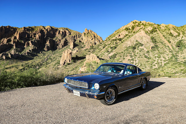
great kind of day for driving a very shiny blue pony car, in fact.
Jane and I headed into Big Bend towards the main visitor center, Panther Junction, which is actually somehow 30 miles into the park. Typical - Big Bend is a huge, fairly decentralized park developed in a very Texan way. That is, it consists of four main “hot spots”, connected to each other by very long roads.
At Panther Junction, I got my plan together for the week, harassing the poor girl at the front desk (who, she later informed me, had just started working there a week prior – oops) endlessly about various driving times, trail options, closures, and the like. To be fair, this is the kind of thing that I could plan out myself prior to leaving on a trip. But I really prefer to speak with one of the “parkies” – interpreters, rangers, guides, whatever you’d like to call the park staff, they tend to colloquially refer to themselves as parkies - when putting together a plan as it feels so much more personal, and so much more like an adventure. Planning everything in advance just makes a trip feel too… canned.
One of the things I love most about parkies is their (usually) unbridled enthusiasm for their park, and their joy at having the opportunity to show it to you. A great ranger can make any day brighter and put a spring in your step for even the most strenuous of hikes. Want to know about river processes, riparian systems, local ecosystems, plants you definitely shouldn’t touch, a weird bug you found, or stars you should look out for at night? Parkies seem to come equipped with all of that knowledge – and more – by default, even on week one! It’s remarkable how much information one can stuff into one’s brain within a short period of time when you’re motivated purely by passion and a love for the outdoors and history. And it is so much fun to learn from them.
Unfortunately, it is sometimes very hard to find a ranger who really knows about the geology of their park. Geology just isn’t many peoples’ strong suit! And as a geologist, that really bums me out. Don’t get me wrong, I want to know about the plants and animals too. But boy, when you have a park that is entirely centered around preserving some really spectacular rock features… well, I wish people knew what the rocks were so then they could tell me! I NEED TO KNOW
And that’s the problem with being a geologist. You take
your work everywhere you go, for the rest of your life.

I'm going to get a lot of use out of this picture in the future, I just know it
But you know what? The GREAT thing about being a geologist is that everywhere you go, if there are rocks, there is a fun puzzle to solve! And figuring out what you’re looking at is a very diverting pastime, especially on long slogs up a mountain. But that part of the trip comes later.
After some consultation, I decided to start my Big Bend
adventure by heading down to Castolon. Located along the central southern
boundary of the park, the Castolon area features a number of homesteads, some
reclaimed farmland, great views of the Rio Grande, and the famous Santa Elena
canyon. And it’s located right at the end of the Ross Maxwell Scenic Drive! I’m
a big fan of scenic drives, especially for first-day orientations and
especially when the weather is this perfect. So off we went rumbling south towards
Mexico, dodging tarantulas and stray boulders along the way while I mused over various rocks in my field of view.
 |
| An awesome angular unconformity |
 |
| I spy a dike |
 |
| Way too much volcanic ash! |
We pulled into the Castolon visitor center in early afternoon – I know, I had literally just come from another visitor center, but I wanted to know what was in THIS one! Turns out, actually very little, as apparently the visitor center had burned down a couple years ago in a brush fire. So instead, I encountered an active construction zone with various services stuffed unceremoniously into whatever outbuildings were available. But parkies are parkies – no matter the circumstance. When I pulled in, someone was already standing ready to tell me about the area, bright-eyed and bushy-tailed despite the dust swirling through the air.
This particular interpreter, who apparently had also started in the past week (I must have shown up at the seasonal switchover), positively overflowed with knowledge about the Castolon area. According to her, she had already been on every single hike in her new domain, and had already figured out when to go back to get the best lighting for each scenic vista she had encountered. “Go to Tuff Canyon in the afternoon, it’ll be shady”, she instructed, followed by, “And I’m already dreaming of a beautiful sunrise through the petrified log fireplace in the ruins of the old Dorgan House!” I found her to be a wealth of information about the history of the region – both in bygone times (various farming ventures) and in modern times (serving as the friendly collaborative border between Mexico and the US). I had a wonderful time talking to her.
But she still didn’t know about the rocks.
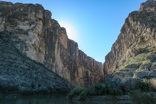
But that’s okay, because the Castolon area is actually the one area of Big Bend that I am very familiar with! Earlier when I said, “the famous Santa Elena canyon”, I mean it both from a tourist’s point of view, and from a geologist’s point of view. To a tourist, Santa Elena canyon is a very impressive tall, narrow, steep-sided canyon chopped straight through a cliff, which also happens to serve as the border between Mexico and the US. You can take a nice easy hike down the US side and check out the Mexico side from across the Rio Grande (it looks exactly the same as the US side… except without the tourists) while various kayakers and rafters float past. It’s very scenic, very awe-inspiring, etc.
But Santa Elena Canyon is also famous to geologists, in particular carbonate geologists! At least, it seems like I’ve heard about it a billion times. It’s a location where you can walk through the preserved remains of a tropical shallow marine shelf – much like you’d find off the coast of Florida today – for thousands of feet, equating to over ten million years of deposition. And thanks to the erosive action of the Rio Grande, the canyon is one of the few places in the region where you can actually walk up the entire section instead of climbing a thousand-foot sheer cliff to see it!
Anyways, nerd stuff. The ranger and I chatted enthusiastically about this for a while longer before I realized that the afternoon was getting on, and I should be spending my time actually out on the hike! So off I went again, determined to avoid visitor centers for at least another 24 hours.
I really love National Park visitor centers.
Jane and I drove down to the Santa Elena parking lot,
skirting massive uplifted limestone cliffs the whole way. Slowly, the canyon
came into view. And slowly, the sheer size of the canyon became more evident.
This is no small slot canyon, carved by flash floods and seasonal creeks. No,
this is a canyon carved by one of the great rivers of North America: the Rio
Grande.
The canyon slashes down through a thousand feet of the most
rigid rock in the area, perpendicular to the massive wall that is exposed today
(which also serves as part of the boundary between the US and Mexico). It
speaks to a time when the river ran resolute, wild and deep and strong. These
days, though, the Rio Grande is a shadow of its former self, its waters
diverted for human use long before they reach this place. During the summer, the
river runs only a foot or so deep – or less – and you can walk right across to
Mexico without even getting your shorts wet. But during the rainy season it
regains some of its former glory, deepening and quickening, making it ideal for
rafting but not so ideal for wading.

That is a very large wall 
Santa Elena Canyon from the beach on the other side of the Rio Grande
Unexpected late October rains had apparently swelled the river, and the normal low-water crossing over to the Santa Elena hiking trail was completely flooded. But no matter, as a quick hike up a draw dog-legs you around the deep part and you can cross through a dry gravel wash. I did so, then scrambled up a scree slope and down the other side to intersect back into the hiking trail. Bit of a bush-whack, but easy enough. From there I took the switchbacks up the steeper, rockier lower part of the canyon walls before coming out on a nice bench that meandered its way back into the depths of the canyon.
I spent most of the hike being very distracted by the cool rocks, which probably looked very silly to other hikers who were enjoying the spectacle of the colossal canyon. Imagine hiking through something this huge, this magnificent, and passing some clown on the side of the trail closely examining a tiny trailside rock on the ground. Fortunately, I’ve never been one to be too bothered by what people might think – even if it does cross my mind.
Anyways, I had more important things to think about!
Mostly, the kinds of fossils I was getting to see. Rudists – a type of very
strange clam that lived 100 million years ago – and oysters abounded, preserved
in wonderful detail.

I'm only including one fossil photo here, because I am practicing self control! Here are a bazillion tiny oysters and bivalves entombed in limestone mud.
But one can only look at fossil oysters for so long
before one’s eyes feel like they might fall out, so I did eventually turn my
gaze to the more commonly-viewed parts of the trail. Santa Elena Canyon gives
one a unique feeling of simultaneous closeness and boundlessness. The canyon
walls tower over you, blocking out the sun, the perpetual twilight permeated
with a sense of inescapability. But from the mouth of the canyon, a vast
landscape dotted with mountains and ancient volcanoes stretches for miles and
miles as far as the eye can see.
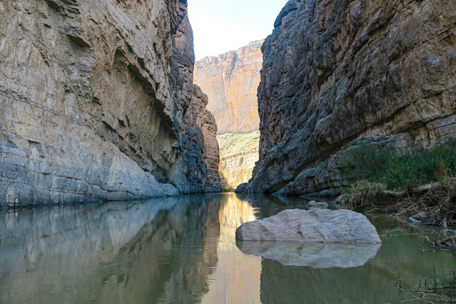
The trail continued meandering down the canyon,
eventually ending at a small beach right on the river. Beds of limestone angled
down into the water and were reflected back in its murky depths.
I sat on the beach for a while with some other hikers, savoring the picturesque stillness. That is, until a child further up the canyon started yodeling.
I hiked my way back up the trail and out into the sun, pausing at the crest of the scree pile to enjoy the refreshing wide-open views after the closeness of the canyon.
And it was there that I noticed, looking down, that there was a family staring up at me.
“Hello,” I said.
“Hello,” they said.
They kept looking at me. I kept looking at them.
Finally one of them chipped in with, “Oh, we’re just
watching to see how you come down this hill! It’s my first time hiking and this
looks pretty scary.”
I looked down at the screed hill. To me it looks like a
pretty average hill, but then again I do spend a lot of time outside. I can’t even
think of when my first time hiking was! What a revelation.
I walked down the hill (normally, because it was a normal
hill), and the family greeted me at the bottom with awe and congratulations (“You
made that look so easy!”). Another revelation.
They were fully geared up – brand new hiking boots,
hiking poles, packs, and the like – so I just said, “Well, it’s easy with
hiking boots, you’ll see. You’re going to walk right up that hill like normal.
Hiking is just walking but on an uneven surface, after all.” Another
revelation!
They seemed immensely encouraged by that comment, and
after that I felt obligated to watch them take a stab at the hill. Unsurprisingly
(to me) and surprisingly (to them), they had no trouble at all and traipsed
right up to the top with nary a misplaced foot. At the top, the lady cheered and
called down to me excitedly, “I MADE IT!!!”
I gave her a huge thumbs up and then went on my way, and
they went on theirs.
I found myself thinking about that funny little interaction the entire rest of the day. You know, I frequently take my outdoorsy life for granted, and sometimes I forget how much so. To me, that was the end of a nice pleasant stroll. To them, that was a big leap, a brave new step into a new world. I hope they had a great hike, and that they were encouraged to do more in the future. Everyone deserves to see the wild and beautiful places in the world.
And hey, it would be a waste of perfectly good brand-new hiking gear if they never did it again.
It really did get me thinking, though, about how lucky we are to have the National Park Service here in the US. In establishing the NPS, we ensured that we would be able to preserve the best of our country for others to enjoy for generations to come. And in staffing it with the best, most enthusiastic, most infectiously passionate people we could find, we ensured that the parks would remain treasured destinations in perpetuity. They are places that continue to spark wonder and excitement and curiosity in our souls, the sites of hundreds of thousands of collective cherished memories and adventures. They were - and are - truly "America's best idea".
Jane and I meandered our way back up the scenic drive (which is much more scenic going north than south, actually) and eventually ended up in the Chisos Basin, our destination for the night. I had scored a very nice campsite right on the fringe of the campground looking out over some lovely volcanic spires. |
| Driving up the Chisos towards the pass |
 |
| Overlooking the Chisos Basin |
 |
| View from the campground |
 |
| Perfection |
As the sun dipped over the horizon, the spires glowing red against the golden light suffusing the basin floor, I threw some hamburgers on the grill and then plopped down in my camp chair with an exciting new book. Jane sat nearby, a comfortable solid presence, the one constant in my ever-changing travels. A light breeze drifted past, carrying all the usual campground sounds – the chatter of campers, the clinking of cookware, the sizzle of grills – out into the basin, to be swallowed by the trees.
It's good to be back out again.
Kelly signing out.


No comments:
Post a Comment