Hello, readers!

Hello, readers!

I am not currently on the road. Please check back periodically later this year as I have no idea when I'll be traveling! August? September? October? Who knows!

Cheers,
Kelly

Wednesday, December 28, 2022

The Hated Hiker


11-9-2022

-------------


I woke up to a perfect Texan autumn morning – warm, with a subtle cool breeze just strong enough to keep you from sweating. The perfect weather for another long day of hiking!

Jane and I puttered up to the Chisos Mountain Visitor Center and I plopped her in their parking lot to be admired, while I hit the trail again. Today’s goal: Emory Peak!

Almost all of the Chisos Mountains trails start from the same trailhead, so I found myself on a familiar path, retracing my steps from a couple days prior. Instead of heading up the Laguna Meadows trail, though, I headed up the Pinnacles trail, effectively going in the reverse of my earlier trek.

Very unfortunately, the Pinnacles trail is much steeper than Laguna Meadows, and it doesn’t let up for miles. I slogged on up through the sloped brushy foothills, up through the rocky forest, up through the endless steep switchbacks (which were even unpleasant to go down two days ago, so you can imagine how unpleasant they were to go up), up, up, up. I would pause at every turn of the switchbacks to have a bit of a breather, then steam up the straightaway to just get it out of the way. Whether or not that was a good technique… well, I did get to the crest of the trail in a reasonable time, so I guess it worked out for me.


Not pictured: terrible switchbacks


After nearly four miles of trudging uphill, I reached the crest of the trail, at a saddle between Emory Peak and another peak. I sat and had a bag of grapes to replenish some juice. Some Mexican Jays gathered around me hoping for a handout, but no dice from me!


Cute

My snack finished, I took off on the trail up to Emory Peak. Fortunately, this portion was a much more gentle grade – at least, in comparison to the earlier steep switchbacks – so I made great time. And once I broke out of the trees, the views were phenomenal!


Boot extra-prominent here

As I headed up, I saw a group of hikers in the distance, silhouetted against the sky further up the ridge. As I watched, they pulled out a bunch of flags – of unknown origin – and jumped about, waving them around enthusiastically. Maybe a quick pump-up pep rally? Who knows. They certainly weren’t at the top, although they were at what appeared to be a very nice overlook.


Also, there were nice flowers in the trail

With the warm sun, the light breeze, and the low-ish grade on the trail, I was really hoofing it. And about a quarter mile before the summit of the peak, I caught up with that gaggle of hikers, finding that it was a group of six or so boisterous middle-aged friends - all carrying Texas flags prominently -  making their way up to the peak. A few were struggling a bit over the bouldery trail, but I was moving fast. And then… I had what might have been the funniest exchange on a trail that I have ever had.

As I came up behind the rearmost member of their party, one heard me turn a rock over and looked backwards. She turned to call forwards to the rest of her party, “Hiker back!! And it’s a young one, moving fast!”

The woman in front of her then turned back, caught sight of me, and said, “Ohhh it’s Mustang Sally!”

Without missing a beat, the woman in front of HER then said, “Ooooooooh we HATEEEEE her!!”

I laughed pretty hard at that one. Never had that reaction to my car or my hiking speed before!

They were (mostly) joking, but I still felt the need to reply, “If it’s any consolation, I’m a career geologist and they fire me if I can’t hike up a mountain in less than five hours”

Which then, of course, led to the rest of the group stopping, clamoring with questions about geology. I evaded the questions neatly with a flippant, “Oh, I’m one of those sages, I can only answer geology questions at the top of the mountain,” and legged it off before they could stop me for too long.

In short order, I made it up to the summit – well, not quite the summit, as I didn’t rock climb my way up the final 10 feet of rock, but I’d still consider it close enough – and had a nice lunch and a bit of a nap after looking around a bit. The view from the top of Emory Peak is pretty amazing on a clear day! It’s easy to see clear into Mexico from here, and there’s all kinds of neat mountains and other geologic features to look at.


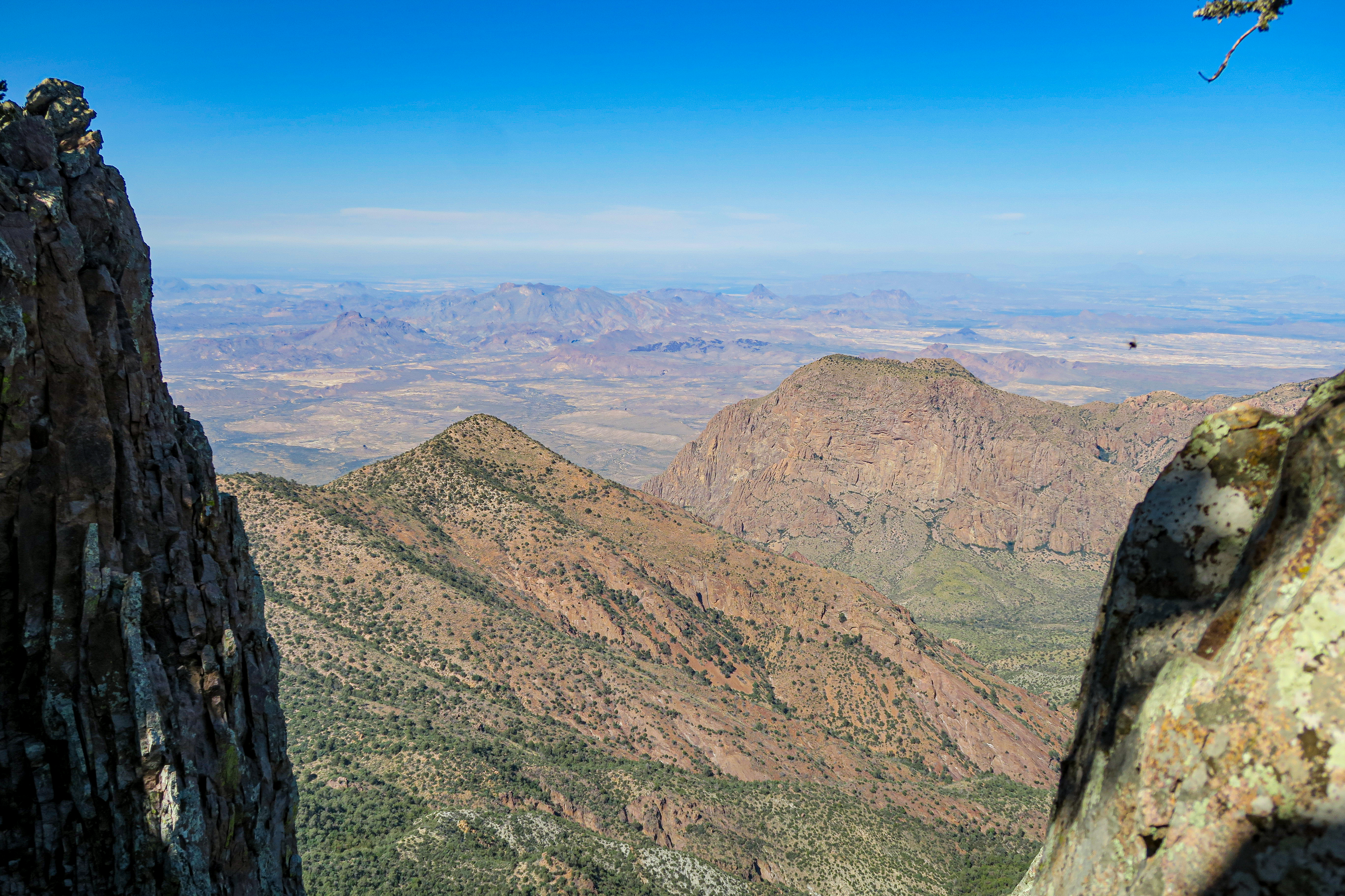
The view from the slot between the two "peaks" (rock outcrops) at the top of Emory


A hell of a view!

A shot of someone climbing up to the very top of Emory's rocky spire. I only went partway up before stopping for lunch on a good boulder


Picturesque in the extreme

Of course, eventually the other group caught up to me, and rightly declared that since I was now at the top of the mountain, I was required to answer their questions. I told them that I was a “soft rocks” geologist (limestone is considered a “soft rock”; volcanics are not!) so I wouldn’t know much about the volcanic rocks of the region. But somehow, for all of the questions they posed, I did have an answer. One of them pointed this out to me – “You said you only know about soft rocks, but you answered all of our questions!!” – to which I replied, “Yes, because all of your questions are answered on the road signs around the park, and I’ve read all the signs.” We all had a good laugh at that one. Sometimes it pays to be the kind of person who compulsively visits ALL of the exhibits, even the little signs on the sides of the road!

I left the summit and hiked back down, glad to finally not be going uphill anymore. It turns out that I took almost the exact same photos going down as I did up, so I guess I didn’t miss any of the good views!


Hmm, starting to look suspiciously identical...


I arrived back at the parking lot early in the afternoon, with plenty of daylight left to burn. I had hiked the 11 mile out-and-back trail in a little over 5 hours – like I said, I was making great time considering the grade of the first part of the hike! I think that the South Rim hike kickstarted me into heavy hiking mode, making all other trails seem pretty short. It’s nice to know that I’ve still “got it”, despite having lived in “the flatlands” of Texas for seven years now. The altitude resilience and the hiking fortitude instilled in me during my time living in Colorado has yet to wear off, it seems.

I thought about heading up to the Lost Mine trailhead again to take a stab at parking, but the awesome patio (and brownie) at the Chisos Mountain Lodge was calling my name again. So I plopped myself down at a table there to hang out for a couple hours. Fortunately I had thought to bring my book with me up to the lodge, so I had something to occupy me between long periods of staring into the mountains. I’m getting better at this whole “relaxing” thing.

As dusk fell, I piled myself and all my books and backpacks and various items back into Jane – noting that the rearview mirror had finally broken after detaching itself from the frame daily for the past two years – and headed back to camp. The mirror is a problem for non-vacation Kelly! For now, my problem is how many burgers I should eat for dinner tonight. And how to address my apparent notoriety in the Chisos Mountain region of Big Bend. "The Hated Hiker", indeed.  

Kelly signing out.

Saturday, December 24, 2022

The Dusty Grumps


11-8-2022

-------------


While I was in bed last night, all comfy and toasty warm, a front blew in. Not a particularly cold front, nor a particularly warm front, but some kind of front… and boy did it blow in with a vengeance.

This is about the time that I figured out the one problem with my Very Great campsite. Perched as it was on the outskirts of the campground, on the edge of a hill overlooking a gully, it was certainly made for great views. But, it turns out, it was also exactly located at the end of the main wind tunnel that funnels through the pass in the Chisos Mountains. And I had gone and placed my tent right at the edge of the campsite, right on the edge of that hill.

Consequently, my tent attempted to depart the planet all night long, as howling winds screamed down that pass and along the gully, banking right up under the rain fly and doing their best to take the tent with them. Fortunately, I stake my tent down pretty rigorously – not to mention, I was in there to hold it down! So the tent remained on planet Earth. Disappointed, the winds carried on without my tent in their grasp, leaving behind a large volume of thick swirling dust which would periodically settle, only to be whipped up and churned about the tent in the next gust of wind.

Now, I can sleep through just about anything. Extreme heat, extreme cold, light, dark, traffic, it’s all the same to me. But it is just a bit difficult to sleep when your tent is periodically laying down on you, creaking ominously, while whipping dust somehow makes it way past your eyelids into your eyes.

I was mostly able to solve the problem by laying my hoodie sleeve over my eyes to keep the dust out. With only the one problem (my tent laying down on me), I was able to get quite a nice night’s rest despite the windstorm.

I woke around 8AM and the wind was still howling. So I opted to hang out and read a book, waiting for the wind to die down. It is really very annoying trying to make breakfast – or any food at all – on a camp grill in heavy winds.

But then the wind just… didn’t die down. At 10AM I had finally had enough so I got up anyways, at which point I found that my contacts were also full of dust when I put them in - a painful discovery. And my fingers were also covered in fine dust, making reinstallation of contacts sans dust completely impossible. A bummer, to say the least.

Tears streaming from my gritty eyes, I made breakfast in the wind, having to chase down various plates and cups halfway across the campsite a few times. I count myself lucky that I only got my oatmeal flipped onto me once.

Needless to say, I was real, real grumpy.

The dusty grumps are the worst. See, if you are grumpy because you’re sodden, or freezing, that’s something that everyone can understand. But many people have never had the experience of just being so gritty that you end up mad, so it really doesn’t make sense to them. You don't realize how horrible it is to have a copious amount of dirt drifting in and out of your eyeballs. How irritating it is feeling sand scrape between your toes, or grind in any other joint, rubbing your skin raw in short order. The annoyance of turning your head and having a small shower of sand stream out of your hair and into your clothes - or worse, into your ear. It is really not my favorite state of being. I think that morning, everyone in that campground began to understand the dusty grumps pretty well.

Having hiked 17 miles the previous day, I decided that I was due for a lazy day. I thought that maybe I would try to hike a couple of shortish trails that start at the campground. But then I remembered that I needed to move campsites (it’s very challenging to book a single campsite for more than two nights in Big Bend), so I decided I would just get that out of the way first. No sense going out on a nice hike, then getting back and getting grumpy again trying to move all my stuff in the wind.

So, I moved my stuff first. Fortunately, the new campsite, although lacking a bit in views, did possess a very large bush that was a perfect wind block for my tent. My poor tent had survived the night’s gale, but not without consequence – one segment of the titanium poles was quite bent, and another had cracked at the end! Nothing catastrophic, but worth babying a bit until I can get the poles sent off for repair.

That done, I opted to set out on the Window trail, which runs down the Chisos Basin and out to the main drainage for the entire mountain range. It’s a fairly popular hike, but not too crowded. As I wandered along downhill through the brush, I encountered several groups of people, all of whom advised me that multiple black bears had been seen nearby. Not on the trail, but near enough to need to keep your head on a swivel.


Alas, I didn’t see any bears at all. But I did see one last late-blooming agave, which was neat. Century plants only bloom once in their lifetime after 10 or even 20 years of growth, so they are pretty rare to see except in places where century plants are abundant.


The trail narrowed as I continued downhill, the sloped brushy hillsides giving way to cliffier terrain and gravel-filled gorges. I considered continuing to be grumpy – especially after having to hike for a while near a group that was playing music aloud, a cardinal hiking sin – but it’s just very difficult to be grumpy when you’re out in nature (assuming you can get away from the people playing music). It was a kind of muggy, overcast day, but even that couldn’t keep me down for long. And other hikers helped stave off the grumps as well – I passed a number of very pleasant people, including a couple with a young child who wished everyone he passed, “Hi have a nice day!”.

Most people are pretty good.

Nearing the end of the trail, I heard running water and encountered a small creek winding down the gorge. It cascaded beautifully down a series of small pools carved into the rock floor, burbling cheerily from one to the other in a path cut by hundreds – or even thousands – of years of erosion.


I traipsed down the smoothed rocky corridor for a while, following the rivulet along from pool to pool. Until, very abruptly, the rivulet cascaded over one last rocky shoulder and vanished completely in a pile of gravel at its base.


Andddddd it's gone

There was not a trace of it to be found further down the creekbed. I assume that there’s a big fracture in the rock under the gorge floor that the water flows through. Fascinating! And although at the time of my visit the creek vanished entirely into this crack, there was a lot of evidence for a massive amount of water flow through the area beyond this point. I would guess that during heavy rains, this area flash floods pretty hard, swelling the creek into a raging river that cannot all drain through that small crack.

A short while later, I reached the true end of the trail – the Window. Although I had been hiking along a basin floor the whole trail – something that should theoretically be a low point – here, it became evident that that was not the case. Although the Chisos Basin is indeed a low bowl in the Chisos Mountains, it is still much higher than the surrounding area! Consequently, a hike along the basin floor to the lowest point in the bowl leads you to the brink of a massive cliff with an awe-inspiring view of the rest of Big Bend.


Now *that* is really, really cool.

I didn’t inch too close to the edge of that dropoff, even though it promised even better views, for one very good reason: the rock there is smoothed almost to glass, slippery and treacherous even when dry. Even my hiking boots struggled to maintain purchase on it. I imagine that thousands of years of floodwaters have funneled brutally through this small bottleneck, battering the constraining rock endlessly in their quest to escape the Chisos Mountains. It must be quite a sight during heavy rainfall.

This would have been a wonderful spot to stop for lunch, if not for the fact that there was already a group of four young teenagers there who had had the same idea. They mostly ignored me as I noodled around for a bit taking pictures and checking out the rocks, as they were embroiled in a daring attempt to rescue a wasp drowning in a puddle.

“I hope this guy doesn’t sting me, but I guess it would be okay. My good karma for the day,” one of them declared.

Most people are pretty good.

Not wishing to bother them, I wandered back up the trail to the burbling creek and had lunch between two of the most picturesque pools. Along came the family with the young child (another “Hi have a nice day!!”), the elderly couple, the two tie-dyed ladies, and a number of others. I decided to skedaddle on so that the end of the trail wouldn’t clog up with people all trying to find somewhere to sit and hang out without bothering others.

The way back up the trail was not as pleasant, mostly because the day had gotten even muggier (in November! In the mountains! Argh!) and it was just a long uphill slog through the brush. But, I got to see some pretty Mexican jays snacking on some worms, so that was neat.


As I hit the last mile of the trail, the sky cleared and I was treated to some very classic Big Bend views. Not a bad end to the trail!


A lizard even came out to warm itself in the sun! This is a Canyon Lizard.


Looks like "The West" to me


Arriving back in my campsite around midafternoon, I figured I would sit and read a while before trying to find parking up at the Lost Mine trailhead – apparently a cool trail, but one with a very small parking lot that fills up fast.

But the more I thought about it, the more I felt absolutely no inclination to go do more assing around. So instead I just kept sitting there in my site, reading my book and enjoying the day. It’s important to do that sometimes, you know. I forget about that a lot in my eternal quest to see everything. But in that moment, sitting in the warm sun, sprawled in my camp chair and burrowed in a good book, I remembered.

At some point, a girl – well, truthfully, probably around my age, but I have trouble referring to even myself as a woman still rather than a girl – approached me, rousing me from my book. She introduced herself as Ginny, a fellow camper who really loved my car. And wouldn’t you know it, but she has a vintage Mustang of her own! She told me all about her car, and I told her all about mine, and then we got to chatting and a very pleasant hour passed. Although it’s common for someone to comment on Jane, it’s fairly rare for the comment to come from another vintage Mustang owner – and even more rare coming from a woman, especially my age! So I was really excited to meet a new friend.

Eventually I popped over to the Chisos Mountain Lodge to suck up some of their WiFi and a power outlet. More importantly, I also took the opportunity to get a warm brownie and some ice cream from their restaurant. A beautiful day deserves a nice dessert, don’t you think?


I wrapped up the day with a nice big bowl of turkey and wild rice soup (which I had frozen at home to use as an ice pack in the cooler – one of my more genius ideas). The dusty grumps had been completely banished. Sure, I was still dusty. There were still some errant specks of dirt in my eye. It was promising to be another windy night. But hey, I had a nice walk, I saw some nice people, I saw some cool stuff, I had some good food, and I’ve got a nice bush to protect my poor tent. Seems like a pretty good life after all. 

Kelly signing out.


Monday, December 12, 2022

The Hike That Just Kept Going

11-7-2022

-------------

After a bit of a chilly night, I spent a leisurely couple of hours warming up in the sun at camp, making oatmeal and staring blearily into the distance as one does in the early morning.

Except, you know, it wasn’t really that early in the morning, it was more like 9. Or 10. What can I say, I’m not a morning person. 

Fortunately, I can afford to dither around in the mornings on camping trips, because I simply just don’t plan too many things for the day. This is a vacation, after all, not a boot camp. Usually.

Around 10:15, I finally got my act together, piled my hiking gear into Jane, and drove all of 3 minutes up to the Chisos Basin Visitor Center just up the road.

BUT I DIDN’T GO INTO THE VISITOR CENTER

(I did stop outside of it, though, to verify the trail map I had was correct)

Instead, I opted to hop straight on the trail and get moving. The weather was perfect, the skies were blue, various birds were singing, the whole shebang. Seemed like a good time to start hiking before I got embroiled in bothering various Visitor Center staff again.

Now back when I was in Terlingua having dinner with Mary and Matt at the Starlight Theater, I asked them what their favorite Big Bend hikes were. And both said that the South Rim Trail was the best there was. They did warn me that it was a bit of a long trek – something like 12 or 14 miles round trip with over 2,800 ft of elevation gain. But no biggie, I figured I’d have no trouble at all if I tackled it early on in the trip when I still had some energy in me.

So off I headed on the Chisos Basin trails, following the signs for the South Rim Trail via Laguna Meadows. Very fortunately, the Laguna Meadows trail is quite pleasant, with nice little hills and a gentle uphill incline – ideal for getting warmed up when you really haven’t been doing a whole lot of hiking recently. And the views from the trail are increasingly spectacular the further you go.


I climbed up through the scrubby meadows and into a more treed section of the trail. Oaks and junipers grew thickly there, shading the underbrush and sheltering all kinds of lovely fall wildflowers, and, oddly, large agaves (century plants). Living here in Texas, I’ve seen a lot of agaves, but I’ve never seen any as attractive as the ones I saw in Big Bend. Perfectly proportioned, with fat subtly patterned blue-green leaves protruding in a very satisfying symmetrical dome, these guys are real show-stoppers. I noticed that they very commonly grow right out of the base of a juniper tree, although I couldn’t tell you why. They are certainly different than the sun-loving giant agaves I’m used to seeing back at home, though.


The most pleasingly symmetrical agave I could find, for your viewing pleasure

By this time – at, oh, about a mile and a half into the hike - the trail had turned quite steep. I slogged my way upwards, trying to remember how to breathe and feeling very out of shape. But still I pressed on, climbing higher and higher. I had things to see and places to be!

And boy, the places I had to see were getting more magnificent by the minute.


Eventually, I had climbed so high that I could see over the mountains in my immediate vicinity, out to the rest of Big Bend beyond the Chisos. A massive wall of limestone – with Santa Elena Canyon prominently visible – loomed alluringly far in the background. But between that wall and my position in the Chisos, it became evident that there was a lot more topography than I had expected.


I found myself beginning to hope that I wasn’t going to have to hike through it.

A series of switchbacks took me through the remainder of the worst of the steep forested area, and I finally popped out at the top of the Chisos. It seems that a large portion of the tops have burned recently – in the past couple of years, I’d guess, based on the plants that have and haven’t popped back up. A number of the burned patches were also suspiciously close to primitive campsite locations. Hmmmmmm. 

Thought the wispy, very yellow grass was neat looking though


Remarkable

I enjoyed a lovely meander – well, still a hike, but it felt like a meander after the rough upwards trek I had just come out of – across the tops of the mountains, heading ever southward. Because the Chisos Mountains are not actually that tall, the tops are not barren as you would see in the Rockies. Instead, they are lovely rolling grasslands dotted with trees and bushes, many of which are not encountered lower down the slopes. The mountaintops might not be that much cooler (temperature-wise) here than on the valley floor, but they are cool enough that they act as refugia for many species of plants and animals that originally colonized Texas during the last Ice Age. As the climate has warmed since then, all of the cooler-weather-loving flora and fauna have retreated to the nearest cool-ish place, which in this case is the mountaintops! And apparently that’s why you can find odd things such as a stand of quaking aspens here.


At about the 6-mile mark, I had reached the southern edge of the Chisos Mountains. The trail popped out at an overlook that was nothing short of incredible.


Talk about a view! And what a perfect place to stop for lunch. I sat and had a peanut butter sandwich and some grapes, which bolstered my spirits enough that I began to consider that maybe I should add on some more mileage to the day’s hike. If you keep skirting around the South Rim (which is ultimately a loop trail), you can dogleg off onto an even longer trail that follows the rim around to the northeast (don’t ask me at which point it goes from being South Rim to Northeast Rim… seems a bit dodgy to me).

I decided to set off and “see how I felt” by the time I got to the fork in the trail. I was keeping an eye on the clock – one minor problem with traveling in the late fall is that the days are shorter, which I definitely forgot about! Well, whatever. Whenever I say “I’ll see how I feel”, it really just means, “I’m definitely going to do it anyways even if it’s a bad idea at that point”.

So off I went. The good news is that once you reach the South Rim, the trail circles around on fairly flat land so you can at least shake the kinks out of your legs and kind of convince yourself that you have a lot of juice left in the tank.

And of course, once I hit the turnoff for the Northeast Rim (or Eastern Rim, as approximately 50% of signage called it), I decided I shouldn’t miss out.

It wasn’t a bad decision at all, though.


I see you, giant limestone cliffs that I want to climb


I wound along the East Rim for a few miles before it took a sharp dive down into a narrow crevasse – okay, it was a totally normal creek drainage, but it felt like a crevasse after spending a couple hours at the top of the world – and finally joined back up with the South Rim Loop. Down in this little drainage, I found water for the first time all hike! Really just little pools of gross algae, but hey, I’m sure it counts for the animals that live around here. No fish, but lots of pond snails, so I’d guess it’s a seasonal creek. But it must exist for a good portion of the year, because the creekbed was crowded with a stand of large water-loving maple trees. Thus, it was there in that little drainage that I finally saw the first sign of fall: the firey scarlet and orange and golden hues of a maple!


I continued my descent back down into the forested flanks of the Chisos Mountains, heading down the Boot Canyon/Pinnacles trail past the Colima cut-through. Not so much to look at for a while except for trees, some nice wildflowers and this very scary building:

Yikes
 
This flower is so red that my camera struggled to take a good photo of it! Awesome

And then the trail started winding back upwards again. I have to say that I was feeling a little sorry for myself by this point, being nearly 11 miles into the hike (counting all of the various detours to explore areas of the rim) with roughly 5 more miles to go. By now it was 3PM, and I was running a bit low on juice – and daylight! I could see the sun dropping in the sky, and wondered if I would be hiking the last bit out in the dark. Not that it would be a huge problem, as I always carry a couple lights, but also not my idea of fun!

I hoofed it up the incline, feeling vaguely distressed (or was it just my body protesting at the prolonged cardio?). But then the trail opened back up to some new spectacular views, and I kind of just forgot about being worried.

The Boot Canyon trail is very aptly named, it turns out.

Dunno man, just don't know why they would call it Boot Canyon

No boots here

The trail ascended to even more sweeping views of the northeastern part of the Chisos, and the world beyond. Towering knives of volcanic rock jutted up from every nearby hill and mountain, while massive limestone cliffs marched across the landscape in the background, defining the edge of the world – at least, my slice of the world for the moment.


At the turnoff for the Emory Peak trail, the path took a downward turn at last and I began my final descent. Steep switchbacks cut down through the junipers mercilessly, prompting me to half-trot my way down to avoid competing too heavily against the effects of gravity. I passed several groups of people who were headed up – presumably to watch the sunset up on Emory Peak – and thanked my lucky stars that I wasn’t them. Going down those switchbacks was not fun, and going up looked even less so!

After the switchbacks, the trail turned more moderate and I resumed a “quick stroll” kind of pace. You know, nonchalant and unconcerned but also maybe moving pretty fast just by happenstance. The shadows were growing quite long, and my dinner was calling me.

I descended past the Pinnacles themselves, and began to feel more optimistic about my arrival time. I stopped to watch some Mexican Jays eat some worms. I stopped to look at agaves. I stopped to look at neat volcanic flows. I stopped to look at great views, and okay views. I found a lot of excuses to stop.

A bit intimidating looking


Check out the layers of entrained gravel in here! Neat


Maybe I was getting a bit tired.

Finally, I reached the floor of the Chisos Basin again, and found myself with enough time left over to stop at a nice bench that someone had placed just off the trail at a particularly scenic overlook.


This is a very nice rock


The sun continued to drop towards the horizon, but by that point I could see the visitor center and I knew that I was almost home free! I’d like to say that I felt a spring in my step, but I was pretty toasted. I did maybe walk a tiny bit faster, though.

And then… I reached a sign indicating that the final stretch of the Pinnacles trail back to the visitor center was closed. I would have to dog-leg around part of a different trail and get back onto the Laguna Meadows trail – the one I started on at the beginning of the day – to reach home base. Hello, unexpected extra mile of walking. Argh, the final nail in the coffin! Well, nothing to do for it but to walk, so walk I did. Fortunately this portion of the trail isn’t hilly. And I did get a chance to see the Laguna Meadows trail at a different time of day.

Compare this pic to the first pic in this post to see the importance of hiking locations at the right time of day to capture the lighting you want!


Finally – FINALLY – I reached the visitor center again! I propped myself up on Jane and considered the day’s hike. It fell just shy of 17 miles round-trip, with about 3200’ of elevation gain. And I had completed it in 7.5 hours. Not bad for someone with a desk job! I had no doubts that I would be pretty tired tomorrow. Jane looked well-rested, at least, having sat in the parking lot being a pretty tourist photo subject all day.

Despite my griping about the length (which I did to myself, anyways) it was an awesome day, and I really loved the hike. I’d do it again in a second (although maybe not tomorrow). The views were varied and spectacular, the trail was a great mix of strenuous and pleasant, and the weather was perfect. I couldn’t have asked for a better day!

After a giant bowl of homemade pot roast with all the fixings, I rolled into bed with a contented sigh.

And that’s when the wind started.

But that’s a story for tomorrow – so until then, Kelly signing out.