10-28
----------------
There are a lot of things that go into determining the
character of a campground. Environment and location, sure, but usually the more
important things are facilities and camp culture. Are the sites clean and
level? Are there bathrooms and are they maintained? Are there people screaming
at all hours, or dogs barking, or ATVs roaring around? All of those things are
usually way more important in determining if a campground is pleasant to be in
or not.
But every once in a while, you run into a campground that is
just so perfectly placed, or is in such an epic location, that those elements
far overshadow everything else.
Bonita Campground in Chiricahua National Monument is very
certainly one of those campgrounds. The facilities are fine – clean, but
nothing notable otherwise – and the campers are pleasant. But wow, the architects
of this park really knew what they were doing (or really got super lucky) when
they placed Bonita Campground. Broad shady trees, perpetually rustling in a
gentle breeze; a secluded hollow that dampens noise rather than amplifying it;
even a creek, mysteriously free of mosquitoes but a great wildlife attractant
otherwise. It is really just spectacular.
There is really something to be said about waking up to the
perfect morning while camping. When you’re living outside, there’s all kinds of
things that could cause your morning to not be perfect. Maybe you wake up to
driving rain, or blistering heat, or freezing cold. Maybe you wake up to a wind
storm whipping dust directly into your tent. Maybe you wake up to a sunbeam
going directly into your left eye. Maybe
you wake up to a bison standing 5 feet away, lowing like its life depends on
it. Or maybe you wake up and find that you’ve slept on a rock all night and
your sleeping pad maybe didn’t compensate for it as much as you thought.
So I feel a deep appreciation any time I get to wake up to a
truly perfect morning. This morning was nearly one of them. It was a cool 70 degrees,
and my tent was perfectly placed to receive gentle dappled sunlight and a light
breeze. The rustle of the forest was unbroken by screaming children or campers
yelling, “HEY LOOK AT THAT COOL CAR”. Birds chirped and sang throughout the
forest around me, a rising gentle melody.
Except that it actually wasn’t that gentle, and there were so
many birds, and all of them were singing to one another in more of a kind of
contest to see who could sing the loudest, so it was more of a cacophony than a
melody. But, you know, almost perfect.
I packed up my hiking gear and Jane and I puttered up to the
Echo Canyon trailhead, high up on the eastern side of the park.
 |
| An extremely picturesque drive |
From this trailhead, I planned to hike the “Big Loop”, which strings together several spans of trail, including “Mushroom Rocks”, “Inspiration Point” (every park with a mountain has to have one, you know), “Balanced Rock”, “Heart of Rocks”, “Sarah Deming”, “Upper Rhyolite”, and “Echo Canyon”. Yes, this is certainly a geology-centric park!
Doing this loop would allow me to see almost all of the trails
in this region of the park, save the “Hailstone Trail” which is named for odd
hailstone-shaped rocks that erode out of the outcrops in that specific area. Intriguing,
but the trail was just not placed where I could include it without missing
something else more scenic.
I started down the eastern limb of the trail, and quickly found out why that segment is called “Mushroom Rocks”. Tall spires and hoodoos rose out of the steep forested hills on all sides, some nestled amongst the trees and others towering above them imperiously, looking for all the world like mushrooms growing among moss. They were heavily adorned by mosses and lichens, the competing orange and green hues warring across the faces of the rock in whimsical whorls. The bright morning sun threw them into sharp contrast, the eastern faces glowing brilliantly even as the western sides were drawn into deep shadow, a study in extremes. They were fascinating – but notably difficult to photograph.


Unfortunately, my camera is really on its last legs, which has been made more and more clear to me throughout this trip. Where it used to take fantastic clear photos, even in low light, it now struggles with high-contrast scenes, poorly-lit scenes, and scenes with many objects arranged at variable distances from the lens. Which, you know, is pretty much all that I tend to photograph. As it struggled to resolve the contrasts of the hoodoos, I began to think that this trail may be the last that it sees. I’ll have to make it a good one.
As I walked, I stumbled across a small innocuous sign on the
trailside reading “MUSHROOM ROCK”. Yes, I was already on Mushroom Rocks trail,
but this sign said “rock”, singular, not plural, and it also had an arrow.

I looked dutifully in the direction the arrow pointed, and saw a rock that does indeed look more like a mushroom than all the others:

I thought it a little silly, but then I looked again at that sign and realized I had seen it somewhere else: in one of the pictures from the CCC exhibits. The sign had been resting in the hands of a young man – one of many holding such signs. I abruptly realized that the sign I was looking at was either the original – now 90 years old – or a very good duplicate. Whichever the case, there was something just a little more special about getting to enjoy a rock that a trail worker had enjoyed nearly a century ago.
The trail dipped into the forest, and for a while I played a
game of trying to spot as many different species of birds as I could. But I
couldn’t take any clear photos of them, which aggravated me, and I’m not a
birder so I don’t know my bird species anyways, which wasn’t super helpful. So
I took a picture of this cool stationary lizard instead:
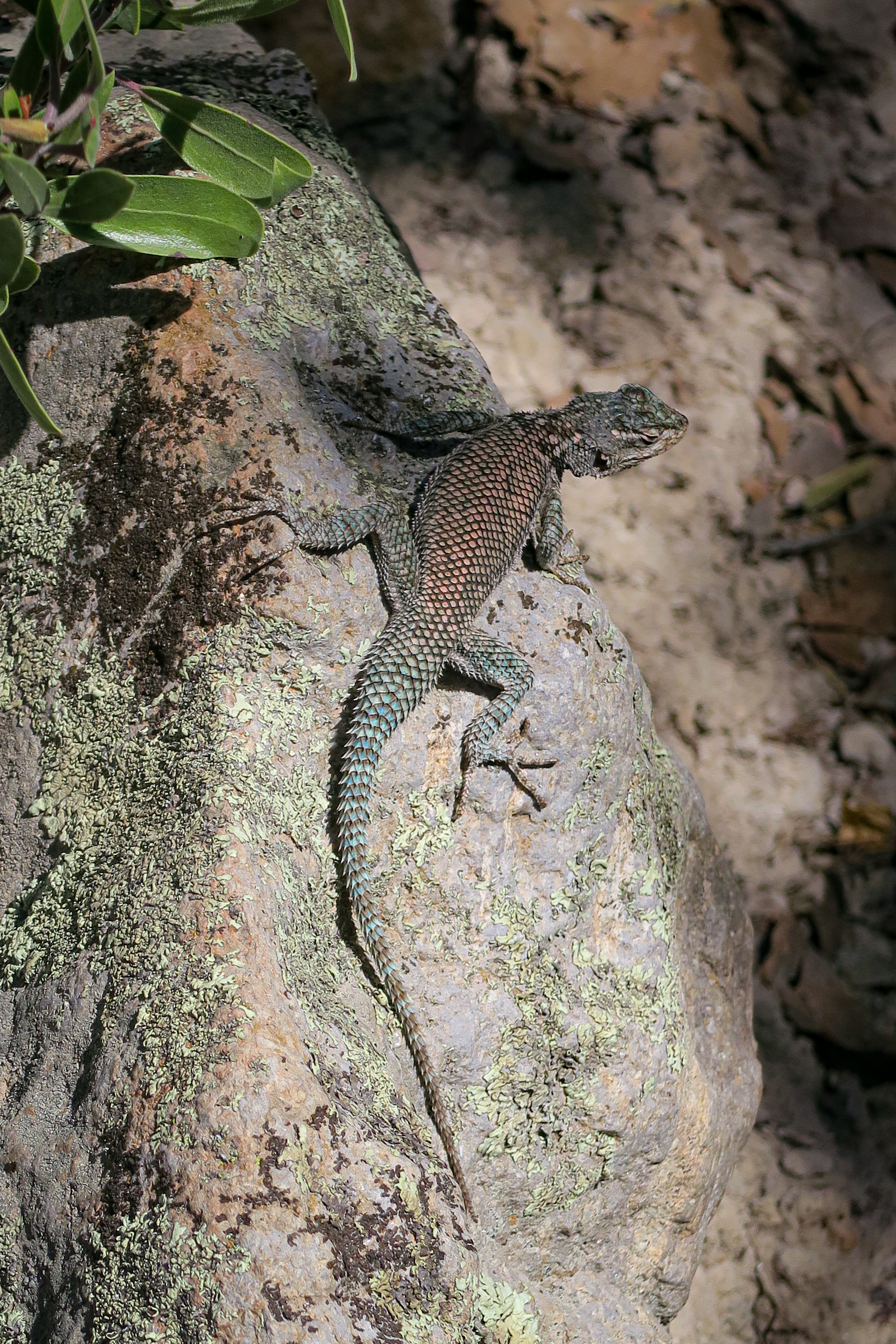
Just be aware that for this one lizard I saw, I also saw probably 20 different species of birds, and successfully took photos of none of them.
As I was traipsing through Hunt Canyon, I ran into a pair of
hikers. After we had passed each other multiple times – I was walking faster
than them, but kept stopping to try to take pictures of the birds – they introduced
themselves to me as Frank and Diane. Both had deep roots in the area, and Frank
told me about how his great-uncle had been a part of the CCC and had built some
of the infrastructure in the park. Talk about cool. Eventually I gave up on
trying to photograph the stupid birds, so I waved goodbye to them and hiked on.
I doglegged off onto the Inspiration Point trail, because of
course I had to. I should keep a scrapbook of every Inspiration Point I’ve ever
been to. Frankly, I’m getting a little tired of things named Inspiration Point,
just like I’m getting a little tired of things named Bonita this, Bonita that. But,
of course, an Inspiration Point is guaranteed to be the most spectacular view
in the park, so I went.
I arrived, and it was indeed very inspiring.
 |
| That's a lotta hoodoos |
I took a single panorama with my phone, turned on my camera to take better landscape shots, and…. Ran out of space on the camera’s storage card. Oops. I plopped down and began to painstakingly erase old photos from the card, which is not an easy task on the Canon I’ve got. I freed up 25 spaces to take further photos, during which time Frank and Diane arrived.
So, they took a very nice photo of me from the top of the
Chiricahuas.
 |
| I've been told this is the "Millennial pose" which I guess makes sense because I'm a millennial, but what the hell else am I supposed to do with my hands?? |
I snapped a few choice shots from the point and sat down for a nice lunch of various random items I had found in my food box. It gets like that, when you get towards the end of a trip. Waste not and all that.


Then I headed back down the trail and further west onto the Big Balanced Rock segment. I expected to see a big balanced rock somewhere in this vicinity, and I assumed it would be Big and Balanced enough that I would immediately know it for what it was upon seeing it. So, I wasn’t particularly keeping an eye out for it, but instead spent my time enjoying the forest, the unphotographable birds, and the spectacular outcrops. But there was one other thing that I really found myself appreciating: the trail itself.
You might think that hiking trails are all kind of the same
thing, in that they take you across kind of rugged, kind of tame terrain and
they ensure that you arrive at the same destination as everyone else. And that
is pretty much true, from that aspect. But a lot goes into making a GOOD trail,
and it is not something you usually see more than a mile away from popular
trailheads. It’s more than just clearing a path: you have to plan out a trail
to ensure that it cuts across the landscape in a way that is comfortable for
hikers, and generally the path of least resistance (to keep them from going
off-trail), but also not likely to impact the local landscape from water
diversion, erosion, etc. A good mountainside trail doesn’t gully out or get
washed away, because it is oriented in a way that keeps it from collecting
water. A great trail will have a good base laid down, with no gravel or cobbles
to turn unsuspecting ankles, and may include structures to prevent erosion where
necessary (small ditches, culverts that run under trails, low walls, stuff like
that). And a truly great trail will have all that, and it will work, AND it
will do it in keeping with the local landscape to keep the path from feeling like
a sanitized contrived trail around a neighborhood pond.
The Big Loop trail is a truly great trail. Not just the mile
closest to the trailhead. The whole thing.
I expect to see truly great trails at big parks like
Yosemite or Yellowstone, where there are engineers dedicated to doing this kind
of thing because it is necessary for the amount of foot traffic that they get.
But I definitely don’t see this at most parks – nothing against them, any trail
is a good trail as long as I get to see cool stuff, and it takes a ton of planning
and labor to make a trail truly great. So it is an extreme oddity to see at an
out-of-the-way small park like Chiricahua.
To take it even a step further – there are many very
well-built trails in the universe, but a lot of them are not maintained so they
do degrade over time. I’ve been on a ton. But this was a trail that was not
only extremely well-planned, and extremely well-executed, but it was extremely
well-maintained. Fascinating. I felt a bit like a crazy person for spending so
much time thinking about the trail construction given the awe-inspiring scenery
around me, but, well, you just notice these kinds of things after a long time
doing this, and once you notice it you can’t un-notice it!
A bit further along the trail, I heard the sounds of
construction – rock saws, and hammering, and laughter. Incongruously, several
miles away from any kind of… well, constructed object. I saw a few people in
distinctive forest-green uniforms headed up the trail towards me, so I stopped
to chat, finding that they were a trail maintenance crew. I was maybe a little
too excited to tell them how nice their trails were, so they were happy to talk
with me about them and how much work they put into maintaining them year-round.
Apparently, the sounds of construction were a second crew redoing a segment of
the trail that kept washing out unsatisfactorily, so they were changing the
switchback and building up some supporting walls to reshape the path. I hustled
down the trail to spectate and found them also very eager to talk about their
work. Whoever the head of maintenance is at Chiricahua – they are doing a
fantastic, fantastic job. I didn’t take any photos because that would have been
a little too weird even for me, but if you ever go to Chiricahua and go on the
Big Balanced Rock trail, I bet you’ll know exactly what I’m talking about when
you get there, even without a picture.
Anyways, enough about trails, back to the rocks. I continued
down the very extremely wonderful trail and it opened up into rockier, more
exposed terrain, and the hoodoos became numerous again.


I saw a couple of interesting balanced rocks, but nothing that screamed Big Balanced Rock at me. Just a bunch of cool hoodoos. I did, however, meet three brothers named Bill, Jeff, and Joe, who were having snacks on the trailside and who offered me a ride back up to the Echo Canyon trailhead from the Visitor Center parking lot (at the lowest point of the trail). They had parked one car at the VC and the other at Echo Canyon so they could do exactly this, and apparently this is a popular thing to do if you’ve got the vehicles to do it, as Big Loop is 8 miles long with a lot of elevation gain and loss (I later looked and found it listed as 1,800 ft). I declined, as I really wanted to see the whole trail, and I knew I could do the hike no problem. My knees might have been a little sore after the Picacho Peak fiasco, but I still had plenty of juice in the tank. So I continued on.
And then… I saw it. It was Big. It was Balanced. It had
another one of those signs pointing directly to it, labeled “Big Balanced Rock”.
And so it was.


A 1000 ton rock, balanced delicately on its narrow tip. Very cool, and definitely worth naming the trail after.
I came to another turnoff and took it to detour around the
Heart of Rocks Loop, which supposedly takes you… well, into the heart of the
rocks. Lol. These people were real good at naming things exactly what they were
(or what they looked like, in the case of Mushroom Rock).
The trail rises up the side of a hill to offer sweeping
views of the rockiest, hoodooiest (new word) part of Chiricahua. Another lizard
gave me the sideeye as I climbed, maybe struggling a bit and considering that
maybe I should give my knees a bit of a break. Maybe.

The loop was worth it, though, with spectacular vistas and
some fun named formations. I saw Duck on a Rock and Punch and Judy, both of
which maybe required a little more imagination than Mushroom Rock – but hey, I
expect that as a trail worker building trail miles away from the supply depot,
maybe you get a little feverish and a little tired and a little delirious and
you start to name things a little more outlandishly. I get it.


 |
| These ones were Punch and Judy |
The afternoon wore on as I stepped onto the Sarah Deming stretch of the trail, which I found to be a very pleasant downhill walk that offered fantastic canyon views. I skirted along the hoodoos on one side of the canyon, too close to see them well, but perfectly able to see their counterparts across the way.


Then, I descended into the bottom of the canyon, well-shaded by large and sparsely spaced trees, the floor littered with their leaves. There were a bunch of interesting trees and bushes there that I wouldn’t have expected to find in this area, but my favorite was the smooth sumac, which had just turned a rich crimson.

The longer I walked through that hushed forest, the more I thought about how I hadn’t seen anyone for… well, quite a long time. Bill and Jeff and Joe were somewhere miles behind me, probably, but I had long ago left behind the trail crews and Frank and Diane, and I hadn’t seen anyone else all day. Exactly how I like it, except when I realize that I’m in prime mountain lion territory, and I’ve left my bear spray in the car.
I hoofed it up out of the glen with alacrity, huffing and
puffing as Sarah Deming Trail turned to Upper Rhyolite Canyon Trail and climbed
back into the stone-laden sunshine. The hoodoos welcomed me back, still a study
in contrasts, although now their western faces were illuminated and the eastern
faces were in shadow.

After a steep climb, I came back out onto the flats, where scrubland and sparse trees competed with hoodoos and small buttes. The trail alternated between traversing across the crests of low hills and threading through gaps between the buttes, and there were many opportunities for interesting compositions with contrasting lighting, though my camera struggled with some of them. A bird even paused for long enough in the underbrush for me to snap a photo!


At one point, I found a very epic wizard’s staff leaning against a crouching outcrop, tucked beneath an overhang.

If I didn’t know it was bad luck to take things from national parks, I would have found some way to shove the staff into Jane to take all the way back home. You don’t find giant cool sticks like that every day, you know.
As I neared the end of the Big Loop, I finally came to Echo
Canyon Grotto. When the rangers had told me about this place, I had visions of
a secluded, damp, moss- and fern-laden rocky shallow cave. But when I arrived,
I found instead a cathedral-like series of hollows, certainly rocky and sandy,
but with no water to speak of and with lichen plastered where moss would have
been.

I wondered if maybe it had ran dry, but later did some googling and found that grottoes are actually not required to be wet! Huh, never knew. Nevertheless, it was a beautiful place. I would have stayed for longer to explore further, but the sun was sinking towards the horizon more quickly than I would have liked (although probably at the same rate that it does every day).

I kept on up the trail with the intent of hopping to another overlook for sunset. I don’t usually do sunsets as I hate returning to camp in the dark - campgrounds are not exactly well-lit, and navigating narrow, winding, non-standardized pathways in a 60’s-era muscle car with no side lighting can be challenging – but as Chiricahua is pretty small, I knew I could reach camp after sunset before the light had fully waned.
I reached the top of the trail to find Jane the only car in
the parking lot, save one of the trail crew’s trucks. The crew popped up as
soon as I walked into the parking lot, and approached me to talk about Jane. I
had the sense that maybe they had been waiting around to make sure that I came
out alright, which was very kind of them. One of them showed me some very cool,
retro-looking black and white photos he had taken of Jane using an old camera
with some filters – he told me he was getting into photography, and Jane had
proven a great subject.
 |
| Have to agree with him, Jane is the best subject there is! |
With that they departed, and I headed on up to Massai Point, the very end of the road at Chiricahua. It’s located at 6,870’ elevation, and provides fantastic sweeping views of the Chiricahua region, although not so much of the hoodoos I had spent the day with. I walked around the nature trail there as I waited for sunset, but it was quite chilly and I had no coat. I always forget how quickly dry, high-elevation climates can drop in temperature. I eyeballed around and, realizing that I had not seen a single cloud all day, elected to forego sunset in favor of going back down to camp (at 5,400’ elevation) for dinner and my book.


So we headed back down the road, winding through the cliffs and forests and keeping a weather eye out for more coatis. I saw a few, including one particularly cute one that trotted serenely up the opposite lane as I came down the mountain. But unfortunately, the light was too low and we were moving too fast for my poor camera.
Back at camp, I took a walk around the forest and fields to
check out some more wildlife. I did manage to get a couple decent photos of the
brightly feathered woodpeckers that frequented the trees around the water
spigots.


Beyond that, I did my best to milk my last night in Chiricahua as much as I could. Despite the fact that I've been on almost all of Chiricahua's hiking trails now, the park still feels like it has so much to offer, and I'm sad to be leaving it so soon. Tomorrow, I'll be back on the road and running hard for home. No more camping, no more fun hikes, just a lot of driving. Boy, I sure would love it if we could invent teleportation machines to transport me across those massive Texan plains!
Until then, Kelly signing out.
No comments:
Post a Comment