8-6
----------
I woke to the start of another hot day – it seems we’ve
arrived back at the standard August climate, for better or worse. After a
couple of eggs at a local Mom and Pop diner, Jane and I hit the road.
Instead of another long slog, I had planned for a short
drive followed by a leisurely afternoon in Flagstaff visiting the region’s
other two national monuments. It’s not fair to visit just the one (Walnut
Canyon) without the others, you know. Especially considering that the three are
interrelated in such an interesting way – through the stories and lives of the
ancient peoples who once called this place home.
We hopped on I-40 eagerly, my eyes glued to the horizon in
search of the distant mountain rising out of the plateau that would signal our
approach to Flagstaff.
 |
| Instead, I saw endless meadows of chollas. |
The three-hour drive seemed positively short in light of the
long driving days I’ve gotten used to pulling, and we arrived at the foot of
that wonderful mountain in what seemed like mere moments. A short climb later
and we were amongst the Ponderosa Pines, their intoxicating vanilla-pine scent
drifting through my open window on that eternal cool Flagstaff breeze.
I turned north towards our destination, planning on grabbing
gas on the way out of town. But alas, the last gas station came sooner than
expected, and I missed it. Apparently.
I found myself viewing Sunset Crater far faster than
expected, before I even hit the entrance booth! I guess that’s to be expected
when you’re looking for a volcano, which is admittedly much taller than all of
the trees and other landmarks in the area.
We approached the entrance booth, where I asked, with one eye
on the uncomfortably low gas gauge, how many miles one could expect to drive
while seeing the park. The attendant helpfully informed me that both of the
parks – Sunset Crater and Wupatki – could be seen in one big 50-mile loop. I
decided I’d risk it, because who doesn’t like to roll the dice unnecessarily now
and then.
First stop in the loop was the visitor center, just past the
entrance booth and campground. There, a ranger oriented me on the available
trails in the park. None of the trails were especially long in the first place,
so I knew I’d have no problem seeing at least one whole park in an afternoon.
But the ranger also informed me that a fair number of trails were still closed
after being impacted by last year’s Tunnel Wildfire, which meant I’d be able to
see all of both parks in one afternoon! Yay, kind of.
 |
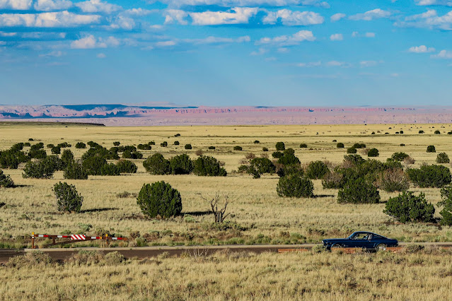
| That is a damn good looking car. |
 |
| This guy thought so too |
A quick turn around the VC gave me the basics of what makes
Sunset Crater so unique. It’s one of the youngest in the States, a cinder cone
that abruptly “grew” around 1085 AD. I say “grew” because these things often
start fairly small, but over time they pile cinders, ash, and volcanic blocks
around their margins as they erupt, effectively growing taller and taller until
they run out of steam (well, more accurately, available magma).
That in itself makes Sunset Crater a notable point of
interest. But what cements it as a noteworthy cultural and natural landmark is
the fact that it erupted so recently that it impacted early human cultures
living in the area. Researchers have spent decades uncovering the story of this
volcano’s eruption and its impact on local peoples. Apparently, it gave enough warning
that people living in the area were able to evacuate, leaving their homesteads
to be buried in ash and lava flows while they watched from afar.
But far from abandoning the area as one might expect, they
returned after the volcano had ceased belching fire and rock. And then, they
learned to farm in the thick blanket of cinders that now coated their land. It
turns out that the cinders are actually good for a lot – in addition to
containing a lot of vital nutrients, they make a good porous groundcover to
help protect crops from drying out or baking in the sun. Counterintuitive, but
a very cool concept!
Jane and I scooted along to the Lava Flow trailhead so I
could see this not-so-deadly volcano for myself. At one point, this volcano was
probably a very tall, very impressive cone. But now, nearly a thousand years
later, it’s weathered down into a rather unimpressive but admittedly
unusual-looking black hill composed of fragments of odd holey rocks. Hmm.
I packed up my stuff – feeling compelled to do so despite
knowing that the full trail loop is less than a mile in length – and set out to
see some more interesting rocks. Even though the volcano itself isn’t too
impressive, the rocks at its base certainly make up for it. The remnants of
lava flows emerge from the cinders, their twisted forms rising tortuously towards
the sky. Many are full of holes, evidence of the expulsion of trapped gasses as
they cooled over the land. Others appear as viscous sludge, forced through gaps
in rocky barriers and extruded into odd shapes.
 |
| An odd-looking rock formation, created when lava oozed upwards through a crack between cooled rocks. |
 |
| An outcrop composed of ash and pyroclastic debris |
 |
| A fossilized lava flow! |
As I walked through the shifting cinders, I considered what
a cataclysmic and life-changing event this must have been, for so many people.
Connected only by the tenuous threads of common trading routes as they were,
imagine how word would have spread amongst the scattered communities of the
Southwest. Would there have been residents in Walnut Canyon then? They would
have undoubtedly heard the explosion, looked out on ash falling from the sky
for days if not longer. But for those further out, would they have seen the ash
and wondered? Would their connections have gone dark for a while, immersed in
the effort of solving the problem of the abrupt formation of a new and very
angry mountain in the middle of their lands? As connected as we are in today’s
world, it is easy for us to hear about disasters across the globe. It’s almost
unfathomable to think of a world in which you might not even know a volcano had
erupted nearby.
Clearly, in the story of these people, resiliency dominated
over fear. They made their peace with the mountain and moved back into its
shadow. But restarting their lives in the wake of such a disaster cannot have
been easy. I surveyed the landscape, which is currently scarred by the effects
of the Tunnel Wildfire. Although there are still many trees intact, it’s easy
to look at the scorched stumps and blasted brush and envision oneself looking
out over a similar landscape a thousand years ago. This is not a hospitable
land, at least at first glance.
 |
| I liked how twisty this tree is |
 |
| This land has seen a similar scene before - and now, nearly a thousand years later, it looks much the same. Volcanic rubble and blasted burned landscape. |
 |
| I found it very unusual how these pine trees were so broadly spaced on this otherwise barren slope of volcanic ash. |
I completed the trail in short order, concluding it with one
last sweeping overview of the crater (and Jane).
 |
| Jane for scale. |
 |
| Damn, that is just a great looking car. Some days I just think about this a lot, as is evident from today's pictures. |
And with that, we had completed the trails available to hike
at Sunset Crater! Kind of underwhelming with respect to length and difficulty,
but certainly a great one to see cool rocks and to immerse oneself in
imaginations of past lives.
Jane and I hopped back onto the loop, heading counterclockwise
towards Wupatki. Once again we descended from the forested terranes of
Flagstaff into the surrounding colorful flatlands of the Colorado Plateau.
 |
| I spy red rocks! |
As we reached the base of the foothills, the visitor center
came into view, and of course I stopped to have a walk around. This one focused
on telling the story of the people who lived in the pueblos overlooking the
plateau. In particular, they focused on Wupatki Pueblo, a spectacular multi-story
structure with over 100 rooms. Although the site has proof of habitation extending
over 13,000 years, it peaked in the early 1100’s when the Wupatki Pueblo and
surrounding region was inhabited by over 2,000 people. That’s quite a sizeable
settlement for that time period! Some of these people were undoubtedly refugees
from Sunset Crater; others moved in to take advantage of the newly fertile soil
derived from the ashes of Sunset Crater’s eruption. The massive population
influx and rise of agriculture turned Wupatki Pueblo into a bustling trade hub,
a waypoint for many other migrating tribes where people could gather and share
news and innovations. Consequently, archaeologists working the site find a wide
array of materials and craftwork artifacts which can be attributed to various far-reaching
tribes that were otherwise disconnected.
By the mid 1200’s, Wupatki Pueblo had been abandoned
entirely due to changing cultures and an extended period of drought. It has
remained abandoned since then, at least until it was temporarily inhabited by
one of the earliest rangers of the park! (and I have to say that I’m very
jealous that someone got to live in the pueblo like that, even if it was
probably bad for it from a preservation standpoint). It’s easy to think that
this was a site that came and gone in a blink of an eye. But really if you
consider the dates, one begins to realize that this pueblo was inhabited continuously
for over a century. The stories these stones could tell.
I stepped out of the visitor center and first encountered a
very sad garden, which presumably was intended to show the beneficial effects
of cinders in agriculture. Unfortunately, this year’s extended, extreme drought
had completely blasted the crops (or someone had forgotten to water them at
all!). But, I suspect that this was kind of par for the course for this area,
sometimes. We’re not in Kansas, after all.
 |
| But this is an especially sad scene in a kind of funny way |
Following the trail around, I encountered a much more
spectacular view: the remarkable remains of Wupatki Pueblo.
 |
| What an incredible view this place has. |
The pueblo consists of a large main building with over a
hundred rooms, plus another few outbuildings and a large circular court. The court
was thought to be a ball court, although it likely also served as a gathering place
for people. From afar, these things all looked like pretty standard-sized buildings.
But as I moved closer, the sheer scale of the settlement really sank in.
 |
| Three or even four floors! Amazing. |
Surprisingly, a number of rooms in the pueblo were open to
visitors to view, an opportunity that I gladly took. It became clear to me that
the people who built the pueblo picked the site based on the presence of a
massive fantastic sandstone outcrop, which served as foundation, floor, walls,
and occasionally even the roof. Why build four walls, when you can build three
and lean them against a massive rock for a fourth wall with 100% stability?
That’s just smart thinking!
This is not to say that anything about this building is “lazy”.
Far from it. The masonry, which looks very similar to that which we might use
on our houses today, is still in incredible condition after nearly a thousand
years. Not only is it flat and tight, but it butts up to the natural sandstone
outcrops seamlessly. Incredible work.
 |
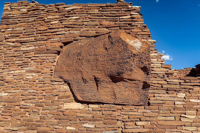
| From the interior of the pueblo, you can see how straight walls intersected the irregular margins of the large sandstone block to use it for stability. |
 |
| An outside wall, also anchored to the other end of the sandstone block in a very pleasing way. |
 |
| An ancient viga (roof beam), still in place. |
I explored for a while, imagining what it would have been
like to live here. For someone in the 1100’s, it must have been like living in
a big city, albeit one with an incredible view in all directions. Perhaps most
days would be filled with farming, but many would be filled with excitement as
someone sighted an incoming trade party on the horizon. Maybe that party would
arrive bringing news of a volcanic eruption, or a great new game, or a new political
agreement between tribes. Or maybe they would come bearing exotic seashell
necklaces from the Atlantic or strange new pottery from the north or beaded garments
from the south. Far from a boring life, I’d bet.
As the sun dipped towards the horizon, I headed back to Jane
to continue around the loop to the next ruin.
 |
| I had to wait for the spectators to leave first. |
My next stop was Wukoki Pueblo, another large settlement. This
spectacular building, although not as big as Wupatki Pueblo, is most notable
for its imposing presence. Built atop a large sandstone pedestal, it features a
three-story tower and a number of well-crafted rooms with very impressive architecture.
If there was ever a Native American mansion… this would be it.
 |
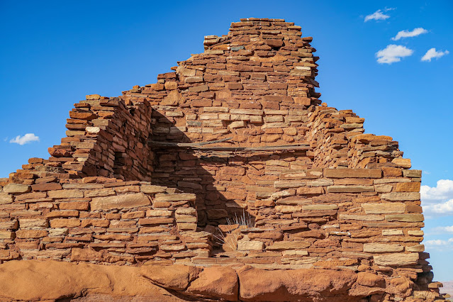
| The pueblo nearly fills the pedestal, with a small patio-like area left clear on the left side (presumably for watching the awesome sunsets) |
 |
| An amazing statement tower |
 |
| Rising from the sandstone pedestal seamlessly |
 |
| Windows with nice slabbed headers. The regularly spaced holes below that are all that remains of the floor structure. |
 |
| A door with great craftsmanship, edges substantially worn by the passage of time and touches of thousands of hands. |
 |
| A nice little keyhole window for light with an exceptional view of the endless plateau. |
As impressed as I was, the sinking sun pushed us onwards, so
we pushed on to the remaining two pueblos.
 |
| But first, I had to look at my car again. This is always the time of day when Jane really shines. |
We reached Nalakihu Pueblo – overlooked by Citadel Pueblo - right
at the Golden Hour, a perfect time for experiencing the still beauty of the
land.
I hiked up to the top of the Citadel, which is perched at
the top of a hill in the middle of a flat grassland. Unfortunately, it is
poorly preserved, partly because it’s located in such an exposed area. But it
is cool to think of what might have been. From this vantage point, one can see
for miles and miles – maybe in the 1100’s, this would have been miles of
fields, dotted with other small pueblos. Or maybe it was still a grassland
then, used for grazing farm animals. Whatever the landscape looked like at the
time, I know that that view was just as spectacular then as it is now. What a gift,
to experience sunsets every day in a place like this.
 |
| Jane in her natural habitat. |
As the golden tones began to wane and shadows crept over the
grasslands, I approached my final stop for the day: the Lomaki and Box Canyon
Pueblos. Located on the rims of small canyons that bisect the plains, the
pueblos look much like watchtowers, sentinels guarding the lowlands.
 |
| Hello, World. |
It’s not hard to figure out why these were placed here. In a
broad flat grassland, how does one keep ones livestock wrangled? It’s not like
there’s abundant trees around for making fences. But a box canyon – a canyon
with only one entrance – is a perfect place to keep your animals. The “watchtowers”
at the entrance to the canyon were likely exactly that – not just residences,
but places where people could keep an eye out for possible hostiles while also
making sure their livestock stayed in the canyon. Maybe not as spectacular of a
view as that from Citadel Pueblo, or as fancy of a house as that at Wukoki Pueblo,
but I bet this was a lot more convenient.
I headed back to Jane and we hustled onwards around the
loop, heading back towards Flagstaff. Very suspiciously volcanic-looking
terrain – now manifesting as innocuous low rounded hills – rose out of the
plains, then eventually gave way to Flagstaff’s familiar mountains.
We climbed in elevation some more, until the turnoff for Fire
Road 545 came back into view. We made our way into Sunset Crater for the second
time today, turning into the campground just before sunset with the usual perfect timing. We
were surely very low on gas, but Jane had miraculously been sipping fuel all
day so we came out a bit better than expected. Whatever the fuel level, it became
a problem for tomorrow, as I found a very inviting campsite and set my gear up
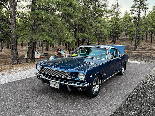
in short order. I was just glad to finally be able to pull out my tent, my old friend - one that has been certainly neglected so far this trip. It's good to be back outdoors and on the "slow" side of the trip, where I can take the time to really immerse myself in where I am.
I watched the sun set over my beautiful, fantastic car,
parked in that beautiful, fantastic scenery, and counted my blessings. There’s
nowhere I’d rather be than here. Sitting by my campfire, the usual Boy Scout hamburger meal sizzling on the grill nearby, I reveled in the onset of night. Fingers of clean, cool, crisp mountain air battled with the smoky heat of the flames and the whispers of hot rendering fat from the grill in a swirling tumble, while the Ponderosas all around me rattled with a rising breeze. This land is steeped in history, and as the day begins to fold and the world draws close, you can feel it rise from the ground, a breath of wind of its own. What has this land seen of the evolution of human history, I wonder. What was it like, in the time of Those Who Came Before?
Kelly signing out.


No comments:
Post a Comment