8-4-2021
A beautiful morning dawned, puffy clouds of pristine white rolling across the landscape and bathing the hills in scraps of shadow. It was exactly the kind of day that would be perfect for more hiking. I would have loved to revisit some parts of the Colorado Trail – maybe taking it up the steep hillside to Little Molas Lake and beyond – but alas, I had somewhere else to be. I had agreed to meet a friend in Ouray for some off-roading.
So I packed Jane up and got her cranked, relieved to find that the smell of burned clutch had finally dissipated. We stopped at the campground entrance for one last shot:

Then, we headed north on Highway 550, passing Silverton and entering the stretch dubbed “The Million Dollar Highway”. Some say that this road is named for its million-dollar views, or for the fact that many drivers wouldn’t drive it “even for a million dollars”. But apparently the reality of its name is much more mundane: when this stretch of road was constructed in the 1920’s, its price tag was astronomical – on the order of a million dollars. This was so shocking, apparently, that the name stuck. Now, that seems cheap to us, so maybe it would be helpful to update its name to adjust for inflation. Why not “The Billion Dollar Highway”?
The stretch of road north of Silverton begins as a fairly standard-looking mountain road with spectacular views:


Jane’s motor hummed quietly (well, as quietly as it ever does hum) as we skimmed down the road, sweeping around the curves and taking in the incredible sights. And then, we were funneled into Uncompahgre Gorge, and suddenly driving took a lot more concentration. Sheer cliffs hundreds of feet tall loomed up from the very edge of the road on one side, and the slope simply fell away without a trace on the other.


 |
| Yes, the road is indeed undercut here due to erosion |
 |
| Yikes! |

My poor little geologist brain churned, trying to take in the geology and understand it (though this type of rock is not my specialty) while also trying to stay on the road and away from rocks and precipices. Jane’s transmission – a 1964 original that is thought to never have been rebuilt – likes to pop out of gear going downhill, which provided an extra element of… interest. Fortunately, my brakes are very good, and I have lived with this car for ten years, which means that I’ve already mastered the art of going downhill half of the time in gear, and half of the time coasting with the brakes, alternating to ensure that nothing gets too much of a beating. You all should be very impressed that I managed to take photos at all while managing all of this, though.
We continued down the gorge for an hour, twisting and
turning through an ever-narrowing gap with ever-steepening edges. Each new turn
brought new sights to drink in, new rocks to ponder. Truly, this highway offers
million-dollar – or even billion-dollar – views for every step of the way. But
eventually the road broadened again and began to flatten out, and I came around
one last turn to find the town of Ouray laid out beneath me. Skirting around a
last couple of turns, we came to rest in this little mountain town on the
valley floor, surrounded on all sides by mountain majesties.


The town was bustling with activity, and I noted that fully 50% of the vehicles – if not more – were Jeeps and other off-road rigs. Ouray is a major hub for off-roading activity, with many well-known trails in the area running all over the surrounding mountain range. Quite unfortunately, we know from earlier this trip that Jane is NOT an off-road rig… so it’s a good thing that I had arranged to ride along in one, instead!
I parked Jane in town in a conspicuous spot – even the most inconspicuous spot becomes conspicuous with a 1966 Mustang parked in it – and met up with Bryan, a very good friend of mine. Bryan was my landlord back when I lived in Colorado, and he still lives here in the summers. I consider him a sort of second father. When he heard that I was going to be stopping in Ouray, he proposed that we go off-roading together, as he has a decked-out off-roading Jeep and had a trail in mind that he needed a spotter for! That sounded like all kinds of good fun to me, so I accepted.
Bryan sent me a link to a description of Black Bear Pass, the trail that he wanted to tackle. I opened it and was greeted with a sentence reading, “People have died on this trail”.
“Hmmm,” I thought, and said, “This trail looks awesome!”, ignoring the large red flags waving about in my view.
So, off we went in his rig.
The start of the trail was fairly tame, offering lovely sweeping views of vast wildflower-filled mountain meadows, small stands of trees, and abundant waterfalls. But the trail steepened and narrowed quickly, and we ascended the first mountain with nothing but sky in view.


At the top of the mountain, we traversed a fairly flattish area with some interesting landscapes that looked nearly alpine to me, with bare-faced mountain caps towering over meadows devoid of trees. I suppose maybe it was high enough to be alpine, although it didn’t feel cold enough to really count.


Somewhere around here, we saw a petite older lady flagging us down. We stopped to talk with her, and she asked for a ride to the top as she was worried that she wouldn’t have enough time to hike all the way up before having to go back down. Of course we gave her a ride. Her name was Carol Anne, and she was sweet beyond belief.
We kept on up the mountain as Carol Anne burbled on about the beauty of the vistas, how much fun she was having, and how grateful she was for us picking her up. She was truly a pleasure to have riding along! Bryan and I were impressed by how far along the hike she had gotten, considering the steep, high-altitude terrain. She told us that she was in her late 60’s. I told her that I wanted to be like her when I grow up.
After a bit, we reached the pinnacle of the trail: Black
Bear Pass, at 12,840 ft. elevation. I suppose we might have been traveling
through alpine terrain after all! All of us hopped out to snap pictures of the
incredible valley laid out before us, with large meadows dotted with alpine
lakes and fringed by impressive mountains. As much as I would have liked to
spend this perfect day hiking, seeing this area was a far better use of such
spectacular weather.


 |
| Bryan said I should have a more artsy pic of myself at the top of this pass, so this is the best we got |
We spectated for a bit and then bid Carol Anne goodbye.
It was time to go down the trail – and this is when the REAL challenges began. At
the top of the descent, we passed this sign:
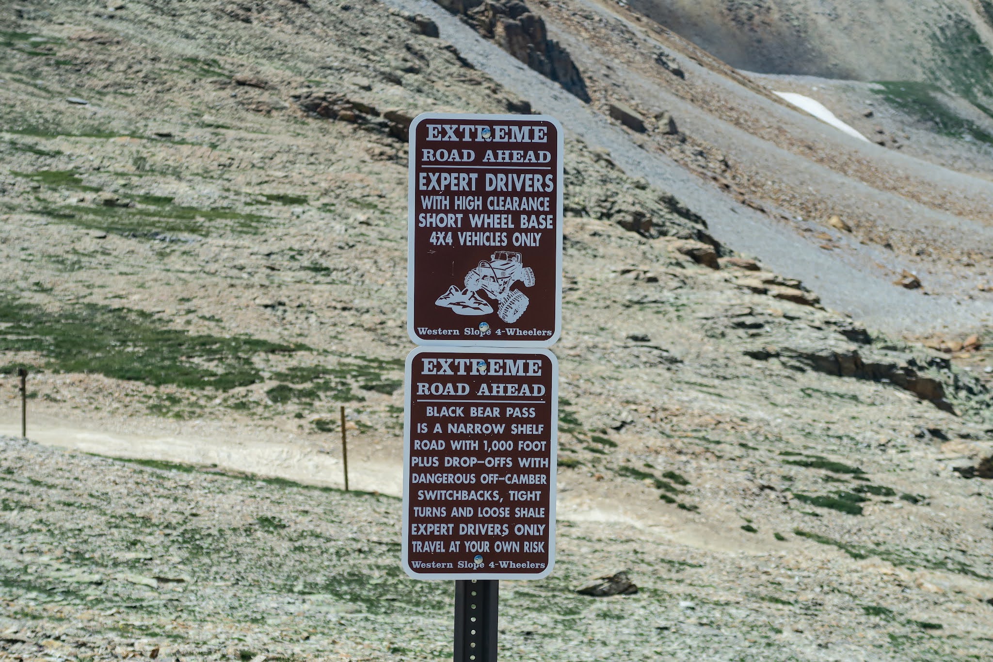
I looked at it, looked at Bryan, and said, “You can drive this, right?”
“I think so,” he replied. After a pause, he offered, “Well, my friend said this trail’s bark is worse than its bite and probably I’ll be fine.”
Satisfied by his alarmingly lukewarm response, I just went,
“Okay, well don’t get me killed man,” and off we went into the wild.
 |
| Jeeps for scale in bottom right |
For a while, things seemed fairly easy. The trail was wide,
if quite rocky, and Bryan’s off-road rig traversed it with ease. But then it
narrowed, and narrowed some more, and it became very apparent that we were driving
on top of a flattened portion of a large scree slope, which was none too
stable. Bryan’s knuckles whitened.


When we got to a lower elevation, the meadows opened back up and wildflowers bloomed in profusion, soaking up the strong rays of the sun. The town of Telluride popped into view on the valley floor in the far distance, a beacon marking our eventual destination. We stopped for a bit, me to take pictures of flowers, and Bryan to shake the tension out of his shoulders.


 |
| Bryan and his rig, a modified 2018 Jeep Wrangler JL |

This group was slowly navigating one of the more technical obstacles in the trail – a very steep off-camber rock face with a few alarming drops. The trail did no favors, providing very limited avenues of approach and sheering off into a steep slope directly off the side. This is the kind of obstacle that you could flip your car on quite easily. Fortunately, one of the drivers had a megaphone and was standing at the rock face and coaching the other drivers through the maneuver one at a time.
Giving Bryan a thumbs-up, I got out and hung off the back right corner for added ballast, ostensibly to help Bryan navigate the obstacle more easily and hopefully stay on all four tires, but also to give myself a much easier bail-out point if needed (hey, survival of the fittest). Megaphone Guy talked Bryan through the steps and sure enough, we came through it just fine. From my perspective, it seemed like hardly any trouble at all. But as I re-entered the Jeep, Bryan informed me that it had not at all felt that way from the driver’s seat. Good thing he’s got nerves of steel!
With all vehicles through the rock face safely, the group
moved on further down the trail. The next thing it had to throw at us – all of
50 feet of driving later – was a more extreme version of what we had already
encountered previously. Closer rock walls, even narrower, even rockier trails, steeper
precipices, deeper yawning chasms, and completely unrecoverable scree slopes. I
took a lot of pictures, just in case we died. Bryan yelled at me for taking too
many pictures because he needed me to tell him if he could get any closer to
the rock walls – he was more willing to scrape his mirrors on the cliffs than
he was to hang a tire any closer to the edge of those scree slopes than needed.
I maintained that I needed to take pictures to document our final moments.


The white-knuckling continued for what seemed like forever, as we navigated hairpin switchbacks requiring six-point turns and narrow straightaways with unstable margins. With so many vehicles on the same hillside, we had to be careful not to knock any rocks free – which could be deadly to someone below.

A gushing waterfall with a largish clearing next to it
provided a very welcome respite where the rest of the group stopped to recoup
and rest. I got out to take a few photos of Bryan traversing the water
crossing, which really was nothing compared to the rest of the trail we had
just come from. Nevertheless, it was picturesque.


While the others rested, we took the opportunity to carry on down the trail without traffic holding us up. And what did we find? Surprise, more brutal switchbacks, narrow trails, and dangerous scree slopes. This was probably the worst part of the trail just for its lack of options. Instead of multiple lines of approach, the trail was so narrow that you only had one way to come at a turn or an obstacle, so you just had to hope that you were good enough to get through it. Very fortunately, Bryan was proving to be a great driver, so we only had a few hairy moments when miniscule inch-by-inch reorientations were needed.

 |
| Well this looks safe |


 |
| Don't mind the gigantic boulder encroaching on the trail, it's fine |
 |
| Who in the world has a turn radius good enough for this? |

And then, unexpectedly, the trail tied into a gravel road, and we got to travel like civilized humans again. We both let out a breath we had unconsciously been holding – although I truly hadn’t felt in danger at any point in time with Bryan driving – and Bryan remarked, “Well, that was the scariest, most technical trail I’ve ever been on!”
Hey, everything works out in the end, you know.
We stopped briefly to check out this great waterfall with
a house-looking building on top (which turned out to be some hydroelectric
deal). According to a nearby sign, the waterfall was called Bridal Veil Falls. Not
to be confused with Bridalveil Fall, which of course is Yosemite National Park’s
famous waterfall. People really are uncreative when they name things.

We had originally planned on taking another, much easier
trail back to Ouray from Telluride, but opted not to as evening was approaching
and we wanted to set up camp. So we took normal people roads home – you know,
the type that’re paved and nicely swept, with painted lines showing you where
to go. The views, once again, were spectacular, and I very much enjoyed sitting
in the passenger seat where I could take photos to my heart’s content. Usually
I’m the one driving, you know, and it’s a bit harder to take pictures when you’re
doing that. A bit.


 |
| Two very different vehicles. Also, the size comparison is laughable! |
This is one of the best things about western Colorado, you know. The wildness of it. The feeling of being in a barely-tamed frontier, just a step away from loss of control at all times. Some might hate that feeling. But I crave it, and others do too – and that’s why so many people are out here. We all want that adrenaline rush, the pride of using your wits to conquer something that could easily conquer us. The feeling of fighting to have any significance in an environment that cares nothing for us. The stores in town might offer safety and society, but a short distance away up the mountains, danger lurks, and it’s real. No canned experiences here. Just unforgiving, raw beauty, America at its best.
It’s been an incredible day. Kelly signing out.
Great story telling; I was literally hanging on the edge of my rocky seat!
ReplyDelete