It rained most of the night but let up early enough for my tent to dry by morning, which I was very thankful for. I hate putting up a wet tent!
I headed over to the visitor center to query the rangers about my plan for the day, and received exactly the answer I expected. There aren't many hikes to choose from on the south rim, on account of you being... well... limited to the edge of a giant hole in the ground, you know. I had already hiked the Rim Rock Trail, and thus had completed 25% of all hikes available. What was left was to hike the Oak Flats trail, hike to Warner Point, and drive the south rim scenic drive. Easy enough to accomplish in a few hours.
I set out on the Oak Flats trail first, since it starts at the visitor center and I was already there. The trail takes you partway into the canyon for some nice views of the wall. Black Canyon has a really cool "marbled" look caused by the intrusion of light colored granitic dikes into darker ancient metamorphic geisses and schists. In simplified terms, millions of years ago a body of magma rose underneath the Black Canyon area, forcing its way into fissures in the preexisting rock. As it cooled, the magma crystallized into granite, full of large crystals of quartz and feldspar. These veins give the Black Canyon the marbled look we see today.


The vegetation was a little dense to get a good view of the canyon walls, which was disappointing. But there were some great flowers and animals to look at, which made up for it! I'm easily amused, I guess. Otherwise, it was a surprisingly unremarkable trail.

 |
| This is my favorite kind of flower - its symmetry is very pleasing! |

 |
| So symmetrical!! |

After I got back from my hike, I hopped between turnouts on the scenic rim drive until I reached the end. Each turnout was largely similar - more marbled brown-and-gray rock with a river at the bottom - and yet each was very, very different. Some turnouts showcased amazing connected dikes, others the roaring river below, and still others the complex arrangement of the walls. But one thing remained the same: the sense of vertigo. Something about the precipitous cliffs and the long vertical lines of the weathered rocks makes Black Canyon seem a lot more imposing. Fascinating, to be sure. But it was very disconcerting to spend the majority of the day feeling as if I was being inexorably pulled towards this giant hole.
 |
| Looking to the east, you can see the difference in the angle of the south-facing (left) slope vs. the north-facing (right) slope. The north-facing slope receives less sun and thus retains more moisture, which increases weathering! |
 |
| Very hard to see, but this picture actually shows 3 or 4 different promontories, around which the river winds. |

 |
| An extra-cool extra-large dike! |
 |
| Supposedly the first people to go down this river did so on a rubber inflatable mattress... I cannot imagine that!! |


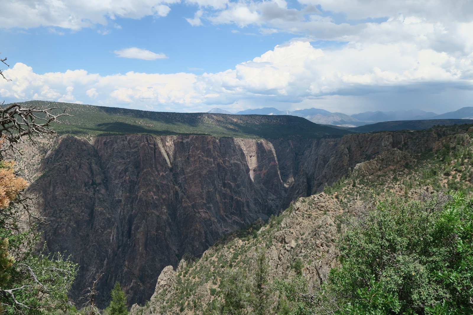
Eventually I reached High Point, the end of the road. I lucked into finding a parking spot and took Warner's Trail out to the edge of the point. Though the Rim Rock trail provides the best views of the canyon, Warner's trail loks outwards and shows you what lies beyond the canyon. From that vantage point, you can see the grassy ledge below the highest point of the canyon, and beyond that, soft gray foothills and a number of towns at the base of the slope. It really gives you a sense of scale that can't be attained just by looking into the canyon. It is hard to remember that the top of the canyon is lifted far above the plateau floor, which is why the river has cut it down so deeply. In essence, Black Canyon is erosion's answer to a tectonic problem.


The overlooks gave me a good view of all of the weather for 30+ miles - and the weather started to look pretty grim indeed while I was up there. Increasingly large bands of rain swept across, bringing thunder and lightning with them. Pretty, but not something I wanted to experience first-hand. So I opted to skedaddle, fast.


 |
| But I didn't skedaddle so fast that I didn't have time to take a few photos of this really cool collared lizard! |
 |
| Hard to believe this is a real lizard that exists in the wild! |
I then instead got the pleasant experience of driving on partially flooded roads on the rim of an exceedingly deep canyon, which was... an experience. Not one that I would want to repeat, for sure. But we did make it down safely though, of course, winding back down the mountains, across the grassy ledge, down the gray foothills, and into the towns below. From there, we looped around to the north and back east.


We wound up in Aspen at dinnertime with rain threatening again on the horizon. I set up camp at Difficult Campground - which was really not so difficult - in record time, not anxious to eat my dinner in the rain.

The forecast for tomorrow is calling for more rain, so we'll see how things turn out. Until then, Kelly signing out!
No comments:
Post a Comment